Ganz unten rechts auf dieser Seite gibt es eine (anklickbare) Weltkarte, auf der ich seit Jahresfrist die Standorte der virtuellen BesucherInnen mit roten Pünktchen visualisieren lasse. So sieht der aktuelle Stand aus:
Soeben teilt mir die Betreiberfirma ClustrMaps mit, daß der aktuelle Kartenstand vor einigen Tagen archiviert wurde und man demnächst wieder mit einer frischen Zählung anfange, damit die Karte nicht unter einer unübersichtlichen Menge roter Kleckse verschwinden möge. Man trage aber Sorge, daß beim Umschalten auf die neue Zählung die bis dann anfallenden Besuche registriert und visualisiert würden, auf daß ich nicht durch eine plötzlich vollständig leere Ansicht des aufgerollten Globus’ einen Schock erlitte. Den kompletten Wortlaut dieser über die Maßen höflich formulierten Mail gebe ich als positives Beispiel von freundlichem Kunden-Service gerne wieder:
| Dear ClustrMaps user, Many thanks for being a loyal ClustrMaps user for the past year. Now that a year has elapsed since your account https://www.zonebattler.net was registrated or archived, we are writing just to let you know that an annual automatic ‘archive’ of your red dots has taken place, meaning that all your ‘other’ (previous) red dots are safely stored in the Maps Archive, which you’ll find by clicking on the Maps Archive link immediately above your large full-size world map. Although the map archive has already happened, your existing map will stay displayed until the NEXT update of your map. This helps to avoid displaying a totally empty map until there are fresh dots to show. We sincerely hope this has not caught you by surprise, BUT we fully appreciate that it may have come at an unexpected moment! You may not have been aware of this, although we do explain this on our Products page listing on http://clustrmaps.com/products.htm and also on our Frequently Asked Questions page, in particular at the following part of the page: http://clustrmaps.com/faq.htm#archivereset The above item in turn contains links to deeper explanations such as http://clustrmaps.com/timeline.htm We know that people always like to have ever-more-dots, but the regular archive is the only way we can avoid having the maps turn into a ‘giant red smear’, and continue delivering the scalable service that everyone has come to expect. The good news is that all of your totals are stored correctly, i.e. the new maps include the old archived totals in the grand ‘running’ total. If it helps to explain things to your own readers, you can always copy and paste the archive map referred to above (right-click and Save as... or right-click and View Image and note the URL and use that), and add that in to the appropriate page near your current active ClustrMaps thumbnail map with a suitable commentary (e.g. »Last year’s totals:«). If this has caught you out by mistake, then we apologise and will endeavour to make this action much clearer in the future. In the meantime, here is wishing you all the best, and thanks again for using ClustrMaps! ‑The ClustrMaps Team |
Gut, das ist eine automatisch generierte Standard-Mail, deren Freundlichkeit die Firma nicht viel kosten mag, aber trotzdem ist offenkundig, daß man hier den Benutzer schätzt und umgarnt. So mag man das, daran könnten sich viele andere ein Beispiel nehmen!






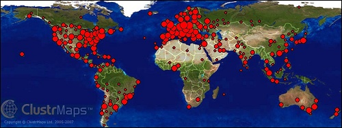
Ich habe die ClustrMaps-Weltkarte jetzt wieder aus meiner Seitenleiste ausgebaut: Letztlich sagt sie nämlich überhaupt nichts aus! Wo immer nämlich auf dem Globus Internet-Anschlüsse existieren, da stolpert über kurz oder lang jemand per Google-(Bilder-)Suche bei mir rein und hinterläßt damit einen Farbklecks. Meist bleibt es aber bei der einen Stippvisite, weil die Leute was ganz anderes gesucht haben, als sie bei mir finden. Mit dem nächsten Mausklick sind sie also wieder weg. Zurück bleibt einzig ihr roter Punkt auf dem ausgerollten Globus.
Und weil das generell so läuft, sieht die Verteilung bei fast allen Websites mit einer ClustrMap (oder einem ähnlichen Visualisierungs-Tool) auch weitgehend identisch aus: Nix los in den leeren Weiten Alaskas, Afrikas, Zentralasiens und Sibiriens (hätte man kaum anders angenommen), wo sich hingegen die Menschenmassen ballen, da tun das auch die Web-Zugriffe. Was Wunder!
Unterm Strich also eine optisch nette Spielerei mit kurzfristigem Aha-Effekt. Und weil sie nix gekostet hat (außer Zeit), sei sie auch nicht weiter schlechtgeredet...
#1
Ja, genau, das wollte ich seit langem tun. Es wird nur voller und voller.
#2
In der Tat sehen sich unsere beiden ClustrMaps zum Verwechseln ähnlich und taugen damit letztlich nur als Vorlage zu einem »heiteren Städte-Quiz«...
#3
Obendrein spielt auch die Datenbasis eine große Rolle, denn wenn zudem die Standorte von Bots und ähnlichen angezeigt werden, ist der Nutzen noch geringer.
#4